
King Schools - Review 4
Private Pilot Knowledge Test Course
Sectional Charts
By Farmboyzim
For some background on what this review is going to be dealing with click HERE.


www.farmboyzimsflightsims.com
FBZFS


Welcome back to the fourth in a series of King Schools Private Pilot Knowledge Test Course Review. The folks at King Schools have been making learning both fun and easy with this course! So far, it's been just John King and I with the lessons presented thus far. John is truly quite the character, as well as a great instructor! His pace is not so much rapid, as it is concise, with every moment of the lesson being filled with well presented information and graphics, making learning this material easy! Just a reminder as to what this course is about:
King Schools Private Pilot Knowledge Test Course Guaranteed Pass! Computer-based Interactive Video� Exam Course: DVD KING�s Private Pilot Exam Course is the industry standard. The perfect combination of solid facts and light humor, presented with KING�s winning strategy, all designed to enable you to pass your FAA Knowledge Test! Click on the links provided on this page to find out in more detail what this great school has to offer!
On with the review! This installment will cover UTC, or Universal Coordinated Time, and Sectional Charts. Time and Charts are very closely intertwined in the navigation world.
The FAA uses UTC for all flight operations. In order for flight times and weather information across the country and world, with its many different time zones, to be standard, UTC is also used world wide so that everyone is on the "same sheet of music". This single time reference is taken from Greenwich, England, which is on the 0 degree Longitude line. UTC was known not so long ago as Greenwich Mean Time or GMT. When applying time to flight operations, the suffix Zulu is added.
What is the difference you ask? Here we go. There is some simple math involved, so if I can do it, I'm sure you can too!
Click Image For Larger View
First off, if you didn't know already, the "24 hour Clock" or "military" time is used when referring to time in aviation. This is simple to figure out. The day has 24 hours in it, so when, say, 2:00 P.M. rolls around, in military time its 1400 Hours. How's that? When you start the 24 hour clock, it begins at midnight, or 0000 hours. Five minutes after midnight would read 0005. Two in the morning would be 0200 Hours, and so on and so forth until we get to High Noon, when a small but important change in time keeping takes place. Remember we are on a 24 hour clock. At noon, the time would read 1200 hours. Notice that in these time references, there are no colons used, and that's not because of a bowel problem! OOOhhhh! Bad joke! Guilty! OK, back to the subject of time! 12:30 in the afternoon rolls around and in military time you would read it as 1230 Hours. Not too different, yet. You fall asleep at your desk (hopefully not at the controls!) and some hours have passed and you see by the "civilian" clock on the wall that it is now 3 in the afternoon! That nap sure felt good! But what about the time? In military time, 3 in the afternoon would be 1500 hours. 11 at night would be 2300 hours, and then midnight again; the clock starts over at 0000. So, what would 4:15 in the afternoon be? Yep, 1615 Hours. For anything after noon, just add 12 to it and you'll get the "military" time. Hope I didn't confuse you too much!
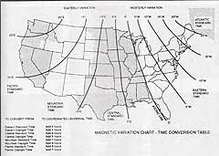
Now for the conversion to UTC time. In making these conversions, unless you have a great memory, you'll need to refer to the Time Conversion Chart at the left. The best way to explain this is by using an example. So here goes!
An Aircraft departs at 1030 PST for a 4 hour flight to an airport in the Central Standard Time Zone. What time will the landing be in UTC? Look at the chart and you will see at the bottom left a conversion table that tells you that to convert to UTC from the Pacific Standard Time Zone, you must add 8 hours. So....
1030 PST
+800 Conversion
1830 UTC
+400 Flight Time (4 Hours)
2230 Arrival Time in UTC (Zulu)
It's really pretty simple, so just practice using the chart with some different times thrown into the equation and you'll be talking in Zulu Time in no time!
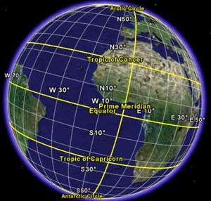
Latitude and Longitude
The figure to the right shows the earth with parallels of latitude starting at the equator and moving up and down the globe, with these circles getting smaller as you approach the poles. From the equator to each of the poles is each, 90 degrees, North or South Latitude respectively, or above or below the equator.
Lines of Longitude, also called meridians, divide the earth from pole to pole, and are represented by the lines that run up and down. The 0 degree meridian passes through Greenwich, England, and are numbered eastward across Europe and Asia, and westward across the Atlantic and the Americas until the 180 degree meridian is reached. There are 60 nautical miles per degree. Each degree is further broken down into 60 minutes, and finally, each of those minutes is broken down into seconds. This is what makes measuring distance accurately, since one minute of latitude equals 1 nautical mile, measured along the longitude line toward either pole. Measurements
for longitude are made using the latitude lines, and measurements for latitude is made on the longitude lines. Sounds confusing, but if you look at a chart you'll see what I mean. It's a reference thing.
Now let�s take a look at what some of those symbols are telling us on our charts.
This symbol denotes an airport that may have fuel. I say "may" because the pumps could be closed or out of gas, so you should always check to see what the status is if you�re planning a stop for juice in the tank! Note the 4 tic marks around the edge.
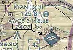
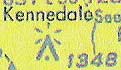
A star at the top of the symbol means that the airport has a rotating beacon.
When an airport has a Control Tower, the frequency will be shown in the group of letters and numbers that are near the airport symbol. In this case, Tucson Intl Control Tower (CT) frequency is 118.3
Airport elevation is given in exact number of feet MSL (Mean Sea Level). This information is also found in amongst the letters and numbers near the airport symbol. It is usually before the lighting information. In the figure to the right, Ryan (RYN) is at 2403 feet MSL.
Obstructions are upside-down "V"'s with a dot.
Obstruction Elevations above sea level are in a bold type.
The actual height of the obstruction above ground level is in parentheses.
Lighted obstructions are presented by a light-flash symbol at the top of the obstruction symbol.
Flag checkpoints are provided on the charts to help identify your position, and are easily recognizable and identifiable landmarks, such as a tall mountain peak, a lake, town, etc. ATC will use such checkpoints in their communications with you at times. There is nothing that is mandatory about these checkpoints. They are there to make your navigating easier.
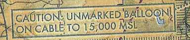
What you might see is the balloon. What you won't see is the considerable length of cable rising from ground level up 15,000 feet MSL! Be alert and avoid these areas by climbing or going around. Wow, that's a lot of kite string!
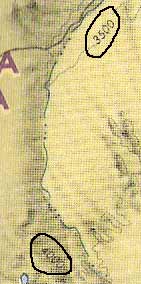
Terrain Elevation is shown by what are called "contour lines� that actually represent the contours of the landscape that is mapped. Between each contour line is 500 feet. There won't be a lot of contour lines next to each other if the land is fairly flat. If you take a cliff for example, the lines would look crowded together like very close growth rings on a tree. Dense lines = Steep landscape. With the figure at left, the terrain varies from the tan area with an elevation of 3500 feet to the darker area, which is 4000 feet.
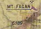
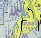
This just looks like it would be dangerous! These tall symbols that are grouped together above the single obstruction symbol represent multiple obstructions that are over 1000 feet in height, and there's more than one! The tops of these obstructions are 2354 feet MSL and rise 1555 feet above ground level (AGL). So if you were flying along with your altimeter reading 2854 (an additional 500 feet of clearance above the top of the object) you should be OK. Don't forget to add the 500 feet to the BOLD number and not the number in parentheses! If you're in a congested area, with lots of buildings and such, the minimum clearance is 1000 feet above the top of the obstruction. By the way, the multiple obstruction symbols apply to the less than 1000 feet obstruction symbols also (the upside down "V" with a dot.).
This is another type of symbol for an airport or airfield, but this is a restricted field, probably privately owned and you would require permission to use it from the owner.
There are certainly many more symbols that were not covered in the above information, but these are the one's that are a must know! Watch for the next installment when we'll cover Airspace and Weather Minimums.
A couple of notes on Beacons...
Military Air Stations will display dual peaked (two quick) white flashes between single green flashes. It's best not to land there!
A lighted heliport's beacon is a green, yellow, and white rotating beacon.
Thanks For The Visit !