
www.farmboyzimsflightsims.com
FBZFS
Click On Any Picture For A Larger View


Thanks For The Visit !
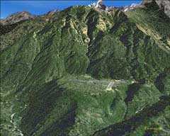
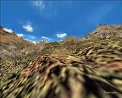
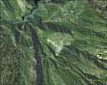
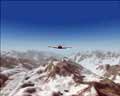
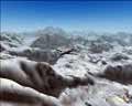
Here's a scenery product that looks so real you can almost smell the crisp, VERY high altitude air! Aerosoft has produced a breathtaking, yeah, that's the right word, breathtaking terrain mesh and scenery enhancement of the Mt. Everest area of Nepal. If you think that it's a beautiful area to fly around in with the default scenery, wait till you get a gander at some of these screen shots! The product covers an area from Phaplu (VNPL) in the southwest corner of the region, up to Mt. Everest, in the upper right hand corner of the region. I looked for a specific area of coverage, but did not see anything in the PDF Manual. I may have missed this however, but the area covered is quite large, with endless valleys to explore, and mountains and ridges to follow. BUT......This is a region not for the faint of heart! This is a scenery package that not only gives you something magnificent to look at, it provides you with an aviation challenge that most real life pilots only dream of, or have nightmares over, one or the other!
Home
Product Reviews
Freeware Reviews
Press Releases
Forum
Articles
Screenshot Gallery
Downloads
Multiplayer Server
TeamSpeak
Tutorials
General Store
Aircraft of the World
Weather
Maps
Links
Certificates
Product Reviews
Freeware Reviews
Press Releases
Forum
Articles
Screenshot Gallery
Downloads
Multiplayer Server
TeamSpeak
Tutorials
General Store
Aircraft of the World
Weather
Maps
Links
Certificates
There are three airports that are included in the product; Lukla (VNL2), Syngboche (VNSB), Phaplu (VNPL), and the Mt. Everest Base Camp Helipad, which is actually any spot you can find in the immediate area!
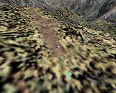
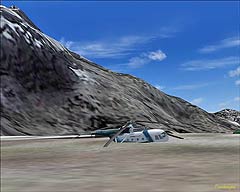
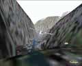
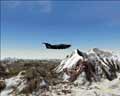
Lukla Airport is the usual jumping off spot for those adventurers that are heading off to tackle Everest. Lukla means place with many goats and sheep, however these days, one is not likely to see many roaming around. The pilots flying into and out of Lukla are adventurers in their own right, for just landing and taking off out of this place! A serious blow to my simming ego was dealt when attempting to land at Lukla! I've gotten better, but there is still the occasional run in with that wall you see behind the DeHavilland, in the image to the right! That wall is the beginning or the end of the runway, depending on whether you're landing or taking off, for there are no other runways cut into this hunk of rock. The runway itself slopes
Lukla Airport is the usual jumping off spot for those adventurers that are heading off to tackle Everest. Lukla means place with many goats and sheep, however these days, one is not likely to see many roaming around. The pilots flying into and out of Lukla are adventurers in their own right, for just landing and taking off out of this place! A serious blow to my simming ego was dealt when attempting to land at Lukla! I've gotten better, but there is still the occasional run in with that wall you see behind the DeHavilland, in the image to the right! That wall is the beginning or the end of the runway, depending on whether you're landing or taking off, for there are no other runways cut into this hunk of rock. The runway itself slopes
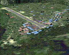
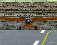
downward at a rather sharp angle in the take off configuration. The challenges posed for landing are pretty stiff, as you have an airfield that has a sheer cliff dropping away 3000 feet at the approach end (don't get distracted by the waterfalls there!), an uphill landing, and a wall at the end of the runway (the wall being part of THE MOUNTAIN!). Make no mistake; this is one tough airfield to master! Due to the extreme altitude and the resultant thin air, you'll find yourself taxiing with a bit more power than usual upon landing, and if you fly with the realism settings cranked up, then you're in for a treat in the manner of an overheated engine if you're not careful! Parking spaces at Lukla are at a premium, as there is only room for four aircraft at any given time. Aircraft used in this region are usually DeHavilland Twin Otter's, and during the "busy" season, October - November, when all the would-be adventurers come from all corners of the globe, this tiny little airport that sits at an elevation of 9300 feet gets rather busy. To be precise, the apron altitude is 9373 feet and the end of the runway altitude is 9265 feet!
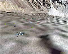
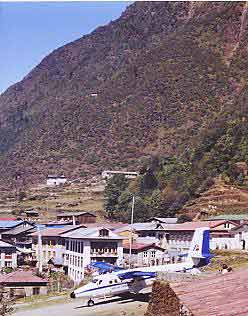
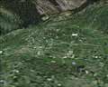
The scenery at the Lukla airport is fantastic, with all buildings based on real images from the area, along with shrines, tents, gear strewn about, and a photorealistic people standing about the parking area (taking their lives into their own hands, if you ask me!). There was, I had noticed, one particular fellow that looked at you no matter what the angle was that you were using in the exterior view. Rather eerie, but a very neat effect! I had mentioned the buildings being authentic around the airport, but that goes for the placement of buildings that are away from the immediate vicinity of the airport also.
The idea for the location of an airport at this location is credited to Sir Edmund Hilliary. When he climbed Everest, he journeyed for weeks just to reach the mountain. Climbers now have the "luxury" of flying into Lukla, and walking 12 days to the Base camp of Everest, which is at an altitude of 17500 feet. The journey to the base camp can be made by helicopter, but not many helicopters can operate at this altitude, because of the thin air. The manual states that the only two choppers that the testers could find that would operate at this altitude were the commercial Nemeth Designs MI-17 and the freeware AS350. To be honest, I did not attempt any helicopter flights for this review. There are some other drawbacks, other than the limitations of the helicopters themselves. Folks taking the chopper flight won't have the opportunity to acclimatize themselves to the altitudes, as there is around an 8000 foot difference between Lukla and the base camp. Altitude sickness is probably a familiar occurrence for those that do not want to take the 12 day walk! About 90-95% of the foreign nationals, who reach Lukla, will arrive by a ˝ hour flight from Kathmandu.
You'll see these dotting the sides of the mountains as you weave your way through on your way exploring! In the PDF manual, which is in English, but also available in French, high altitude flying is covered with quite a few tips and tricks for operating in and out of this area. I would suggest reading the manual, as it is only 18 pages, but has information that you really should be aware of. More on the manual later in the review. Depending on your autogen and scenery settings, this area can be a "frame rate eater" for slower systems. For the review, I had settings at their highest; to display all there is to see. Taxiing with these high settings however, even for my system, proved to be quite a task. Experiment with your settings to get the best frame rates. Even after I toned down the settings, the beauty of the area was still there in all its glory, just a few less buildings. The developers did an outstanding job in recreating this airport and the surrounding area! Very impressive indeed! Here's the scoop right from the Aerosoft site on the product...
Lukla - Airport at the top of the world features:
·Lukla airfield with its spectacular very short, very sloping runway, at 9000 plus altitude.
·High definition mesh for the entire area.
·Based on commercially available satellite image (expensive stuff, believe us).
·Lukla village in great detail.
·Nearly all villages in the area at their exact location with every single house based on official Nepalese maps. Nepalese style and not standard autogen of course.
·High resolution mesh terrain and texture resolution of Mt. Everest Mountain provided by no other commercial add-on
·Mount Everest base camp (helicopter destination) and other camps higher on the mountain.
·Two additional strips nearby; Phaplu and Syngboche (closed because of protests of the locals, but even higher than Lukla at 12286ft!)
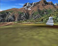
·Some of the villages have typical Nepalese stupas (shrines) and the famous Tengboche Monastery at the Everest trekking route is included.
·Not a single road in the scenery!
·Two missions dangerous enough to get you killed.
·Manually placed landclass, plus all rivers and lakes.
·Extensive English manual, with chapters on high altitude operations (available in French, too).
Lukla - Airport at the top of the world features:
·Lukla airfield with its spectacular very short, very sloping runway, at 9000 plus altitude.
·High definition mesh for the entire area.
·Based on commercially available satellite image (expensive stuff, believe us).
·Lukla village in great detail.
·Nearly all villages in the area at their exact location with every single house based on official Nepalese maps. Nepalese style and not standard autogen of course.
·High resolution mesh terrain and texture resolution of Mt. Everest Mountain provided by no other commercial add-on
·Mount Everest base camp (helicopter destination) and other camps higher on the mountain.
·Two additional strips nearby; Phaplu and Syngboche (closed because of protests of the locals, but even higher than Lukla at 12286ft!)
·Some of the villages have typical Nepalese stupas (shrines) and the famous Tengboche Monastery at the Everest trekking route is included.
·Not a single road in the scenery!
·Two missions dangerous enough to get you killed.
·Manually placed landclass, plus all rivers and lakes.
·Extensive English manual, with chapters on high altitude operations (available in French, too).
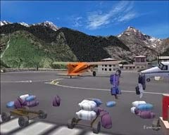
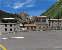
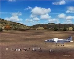
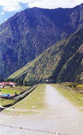
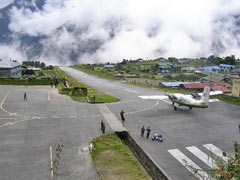
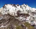
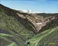
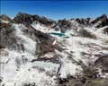
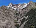
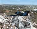
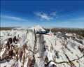
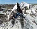
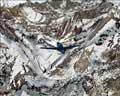
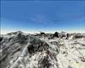
Lukla is not the only challenging airstrip in this neck of the woods! As you can see by the screen shots below, VNSB, VNPL, and the Base Camp Helipad at Mt. Everest itself, all offer their own unique characteristic, as in short, rough, and rather oddly placed locations (sides of mountains!). This area is the ultimate for the "bush-type" flying that some of you enjoy, and it's simply beautiful scenery, even if you're not into bush flying!
When comparing the real pictures of the region and airfield to that which is rendered in the product, I was very impressed! Not only an excellent job was done in recreating the villages and various buildings, but the mountainscapes are simply great! If you happen to catch me on the multiplayer server, this is where I will probably be exploring for awhile! I do believe there are endless hours of flying time that can be spent poking around these mountains and valleys!
The only glitch that I could see was that of my not having a fast enough graphics card to run everything maxed to the limit on my autogen settings! For those of you who are new to the sim, autogen is the setting for the amount of buildings, trees, etc, that will be displayed when flying. The higher the setting the more you see, but the frame rates take a hit if your card can't keep up. Toning the settings down resulted in smoother movement of the aircraft, and still had loads to look at! Some of the buildings and effects just might not be displayed, which should be no problem, unless you're planning on sticking around for a hot brandy by the fire at the inn! Some scenery products are meant to be viewed with high settings and at times, toning down the settings will not enable you to really enjoy the product without a fast computer. Not so with the Lukla product. Even so, I do need to get myself a faster card one of these days! There are some other minor issues covered in the FAQ's like no winter season textures, which is due to a limitation of MSFS. I was very pleased with the "performance" of this scenery add on!
Obviously, if you are into bush flying or love to fly through breathtaking scenery, this is the package for you, and it is downloadable from the Aerosoft site. It's a pretty simple process, and they walk you through it easily! Download-Version of the product is 31 MB and costs USD $21.77. I think this is a great deal for such a product. The quality is certainly there, and the price is right! Check out more information at Aerosoft’s website, where they have a couple of videos of the product that I think you will enjoy watching. Oh yeah, and keep an eye out for the Yeti! I think he owes me 10 bucks from a card game!
Here are some more shots of the area. I have to say that this was yet another one of those scenery products that made it quite easy to go "screenshot crazy"! I think I originally had something like 150 shots to go through! Here are a FEW of them!...
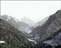
There are more and more scenery packages these days, that will feature not only an enhancement to the default terrain and textures of MSFS 2004, but they also pop in some tasks or other nifty things to do while flying in the enhanced area. In the case of the Lukla Product, there are two "missions" provided for you to fly. One being a search for a downed helicopter and any survivors, the other being a job where you are hired to fly a person (who probably has nothing better to do!) around some coordinates where the famous "Yeti" had been spotted. Weather is not optimal for this flight, but the cash your passenger holds in his virtual hand is, so you take the flight! I personally did not see the Yeti, but I'm sure he's out there! All of the information that you will need to operate in this region is included in the PDF Manual. Especially handy is the small but concise section on high altitude operations. There is also a FAQ section that deals with some known issues with the program. As an example of one of these issues, is that when selecting the Lukla Airport while creating a flight, you will see two listings for Lukla, VNLK, which is the default Lukla, and VNL2, which is the Aerosoft addon scenery. Selecting the default Lukla will probably find you sitting beneath the runway, for choosing the default will cause a conflict, so just choose VNL2 and all is well in the Everest region! Also included in the manual are some pretty good suggestions for taking off and landing at the Lukla Airport, again it's worth mentioning that it would be wise to check the manual out before attempting to land at Lukla. Here's a couple of shots of the real Lukla Airport that were posted on the web by Chris Solnordal, who gives permission to redistribute some of the shots...
A good, downhill, rolling start!
3000 foot drop off at the end of the runway
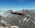
There's a mountainside on the other side of those clouds, right? Please Captain, tell me you see it!
(Click this pic for a larger view...)
(Click this pic for a larger view...)
Aerosoft's Lukla Scenery Addon
Reviewed by Farmboyzim
Reviewed by Farmboyzim