
Horizon Simulations VFR Dallas / Fort Worth
Part of the VFR USA Series
Reviewed By Farmboyzim
Texas is BIG, and it's FLAT! Well, not entirely flat, there are hills and mountains in certain parts of Texas, but really, for the most part, big and flat! This is not to say that Texas is not a beautiful state! I was stationed in Texas many years ago, and traveled both by car and small plane, and the countryside extends for as far as the eye can see, literally! Texas has a lot to offer as far as scenery goes, just not the mountains like you'd find in Nepal! Being a flat landscape can offer particularly different challenges to the VFR pilot. You must rely more on terrain features such as lakes, rivers, roads, etc. Man made features play an important part too, in this flat terrain. You've got to keep your eye out for roads, buildings, developed land, such as parks, and my cousins pick up truck up on blocks in the middle of the field. Well, maybe most maps won't have his truck as a landmark, but they should, its been there long enough!
VFR Dallas / Fort Worth is a great package that will offer you this kind of flatland navigation. They have done a great job with providing various details and landmarks in the 9,300 square miles (24,000 square km) of detailed terrain and aerial photography of the Dallas / Fort Worth area.
The best way to get the most out of this product is to follow there advice for settings, and then go ahead and play around and see what settings are the best for your own computer. There are so many combinations of settings that it would'nt make sense for me to advise you on what you should do as far as settings goes. Just follow there directions during install, which will make some adjustments in your fs9 configuration files. You'll have options regarding whether or not you want these adjustments made automatically during install. I opted to have the changes made automatically, but I always back up everything anyway! You can go in later and configure the changes yourself if you wish, they tell you what to do in pretty simple terms. Install took about 12 minutes or so for me. There's 1.6 GB of data that has to be uploaded to the system. There are some pretty intensive products out there that can chew up a few Gigabytes, and take upwards of an hour to install. Of course, some of these products cover very large areas, and quite a lot of terrain features and mesh. VFR Dallas / Fort Worth is a nice, tidy, package. You will be asked for the installation options also, of various areas of the product coverage. This way, if you have to watch your megabytes, you still can enjoy each of the areas in turn, at your leisure. With my own particular settings, after the initial "test flight", I went back and did some fine tuning, tweaking a couple of display settings up a notch or two, and the results were great. Overall, it didn't take too long for it to be up and running, and I did like the options of what areas you could load.
All major, lakes, rivers, and large bodies of water in the covered area were "hand-cut" by the developers, and are provided with moving, reflective water textures. Lots of these lakes are large enough for float plane landings. You're given an option here also, regarding the display of water, either the interactive water that I have described, or the water from the original photography.
VFR USA is entirely compatible with existing airports and any other add ons that you may have. They have replaced the surrounding scenery of airports with the real aerial photography and elevation data. This way, the over 180 MSFS default airports are also covered. there are also no issues with additional add ons from other developers who use photographic detail.
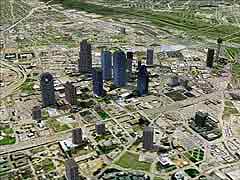
For me, the best way to view this great scenery is at about 2,000 to 6,000 feet, at about 90 - 110 miles per hour. This way the scenery has a chance to load. When you view the scenery, you see what the pilot that was taking the pictures basically had seen. That's what is meant by "photographic scenery". They utilize a 30m elevation model, which adds depth to the photographic scenery and topographic detail.
The aerial photography that was used to create this product was provided by Phoenix based, AirPhotoUSA. Your sim flights will probably look best flown in the summer months, during the mid-day hours, since this was the period of time that the aerial pics were taken, to provide the best clarity possible. If you fly this region during any other time of the year, MSFS will simply add variations of color and brightness. Night lighting is not provided in VFR USA Dallas / Ft Worth, so you may want to disable the scenery in especially dark conditions.
The manuel that is provided gives you everything you need to know in a very consise, easy to read format. They cover everything from installation to settings, and also includes a list of the many airports that are in the coverage area. Hints, tips, and contact information is also provided.
I really enjoy "flying" in this area. It brings back memories of the army days for me! We sometimes had the use of a dual turboprop aircraft (I just can't remember what it was!) that would zip us around Texas and Oklahoma. I was always amazed at the expansive scenery that's in that huge state! I'm a country boy (can't you guess by the name?) and I enjoy flying over scenery that is squares of beautiful fields, and wide open sky!
Again I'd like to point out how invaluable scenery packages like VFR Dallas / Ft Worth are in helping you to prepare for that VFR license that we all would love to have! Even if you have your license, these products offer you the opportunity to "check out" the area that you will be flying in and through, since it is photorealistic!
The price of this package is $29.99 USD, which seems pretty average for these type of add ons.
SYSTEM REQUIREMENTS:
Minimum Specifications
Software FS2002/FS2004
Operating System Windows 2000/XP/ME/98
Processor 700 MHz
RAM 128 MB
Graphics (Video) Card 16 MB
Graphics Drivers DirectX 8.0a
Hard Drive 650 MB to 1.8 GB
Disk Drive DVD-ROM
Recommended Specifications
Software FS2002/FS2004
Operating System Windows XP Pro
Processor 1 GHz
RAM 512 MB
Graphics (Video) Card 64 MB
Graphics Drivers DirectX 9.0a, or later
Hard Drive 1.8 GB
Disk Drive DVD-ROM
For more information on this great add on visit: www.horizonsimulation.com
Click the Picture To See More Screenshots

FBZFS

www.farmboyzimsflightsims.com

FBZFS
Thanks For The Visit !