
Farmboyzim's Flight Sim's
Real Germany Region 3 South East
By Aerosoft
Review By Farmboyzim
This is my first aerosoft product that I have used and reviewed. I'll tell you right now, I want more! Does that sound greedy? If it does, I can't help it! This scenery add on is just beautiful! Germany is a country with a variety of landscapes. While in Germany for a couple of years, I was fortunate to see quite a bit of it, and enjoyed every moment! I would have enjoyed it even more if I had the views that I did while "flying" in the region that's covered in this third package in a series. Aerosoft states that their hope is to cover all of Germany in this series.
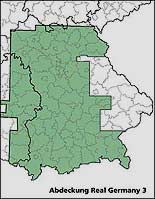
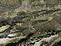
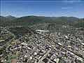
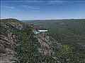
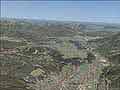
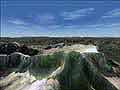
The area covered in this package is that of Bavaria, with the exception of eastern Bavaria. It extends from Franconia in the north to the "Zugspitze", the area of Berchtesgaden and the Allgau. Having been to that area, I really wanted to see the Zugspitze again! It's been 25+ years since I've been there, but it looked like what I remembered! Awe inspiring! I'm talking about both the "real" mountain range and the scenery add on! There are two very conveinent flights that are set up for you in the Flights of MSFS. The first is a 30 minute flight that takes you from the airfield Vogtareuth, which is situated about 8 nm northeast of Rosenheim, southward over the lake Chiemsee, to the Kampenwand, and then via Rosenheim, it's back to the airfield where you began. This flight is abundant with panoramic views. The peaks of the Kampenwand reach up to 5476 feet and provide a spectacular view. After the mountain ranges you'll descend to 3,000 feet and head to Rosenhiem, a large city. The developers didn't just pour all their efforts into the terrain mesh. The towns, cities, landscapes, even the cleared areas that run under the High Voltage Towers are there and clearly seen and accurately placed. A BIG plus for you VFR fliers
out there! Follow the Autobahns, rivers, or valley's with an accuracy to detail that is very impressive! The ability to use ICAO charts and maps is made possible by the detail provided. Included in the package is a set of maps/charts that can be used for this region. They are detailed and easy to read, and fun to use I might add! That's the fun of VFR flying, the challenge of matching what you see on your chart, to your relative position and time. No FMC's please!
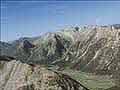
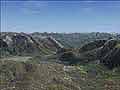
The second flight is the one that I jumped into first, and that takes you from a position that is southeast of the peak of the Zugspitze, at an altitude of 11,700 feet, to an airfield north of Munich. The flight is about 35 minutes, but I got seriously sidetracked with what there was to see! When I finally got back on course, the flight takes you over Garmisch and past some beautiful lakes. This is a valley cruise, and the scenery is spectacular! The default aircraft is the Cessna 172, but you can change aircraft if you desire.
Real Germany was developed by the company GeoContent using digital aerial pictures, which gives a resolution of 4m per pixel. This contributed to the incredible accuracy of the landmarks that can be seen.
Summer textures are represented in this product only, because of the huge amount of data that is used already. The manual states that in the winter, you will not see any snow, but a difference in landscape due to lighting conditions. I'm not sure what I did, or didn't do, but, as you can see in some of my screen shots, there is snow on the mountains, and beautiful at that! So on this, I'm not really sure of an answer why, but I'm not complaining! Loading times increase with these add ons, so be patient if it takes a couple minutes to load. Go over your flight plan while you're waiting!
The manual that comes with the product is clear and concise, with installation instructions.The install was easy, but took a little time, as most scenery products do, because of the size of the files. Don't lose the disc envelope, for it has the product code on it that you'll need to enter during the install. Real Germany can only be used under the FAT 32 or NTFS systems, which normally are in use from Windows 98SE to XP. In this case, they call for 3 GB of free hard drive space. System display settings are discussed for maximum performance, but due to the variety of systems that are in use, you need to experiment with your settings to get the most out of your own particular system. The two flights that I mentioned are covered in the manual in detail, so you can get the hang of what to look out for, and note the particular landmarks that are referred to. German and English are presented in the manual.
System Requirements:
* Pentium 3 with 1.3 GHz or AMD equivalent
* 3 GB free hard disc space
* File system FAT 32 or higher
* 256 MB RAM Memory
* DVD Drive
* 3D Graphics Card with 64 MB RAM
* Sound Card
* MSFS 2004/2002
* Windows 98 SE,2000, ME, XP
This scenery package ranks well up there amongst the best in my opinion. The cost is $32.39 USD or EUR 29.99. As far as the price goes, I think it's pretty competitive with what's out there on the market now, and it's certainly worth the money!
For more information on Real Germany 3, click here.
For other products from aerosoft, visit them at www.aerosoft.com.
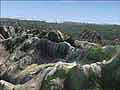
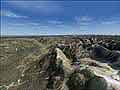
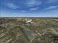
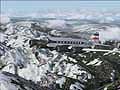
With scenery products, you try to include the specifics about the product, the area covered, details, etc., and whether it's good or bad. But what I think conveys the quality of a scenery product best, is in the pictures! So here's some screen shots from the product, that I took on some of my "flights". This was one of those situations where I went "screenshot crazy", AGAIN, so these are only a few of those that I snapped. Be sure to check out their site for more shots and info!

Click Picture For Larger View

Thanks For The Visit !


