- Home
- Product Reviews
- Articles
- Tutorials/How-To's
- Movie and Book Reviews
- Downloads
- Forum
- Aviation Video's
- Flight Sim Video's
- Multiplayer Server
- Team Speak Server
- Screenshot Gallery
- Maps
- FS Links
- Certificates
- ICAO Codes Index
- Weather Info
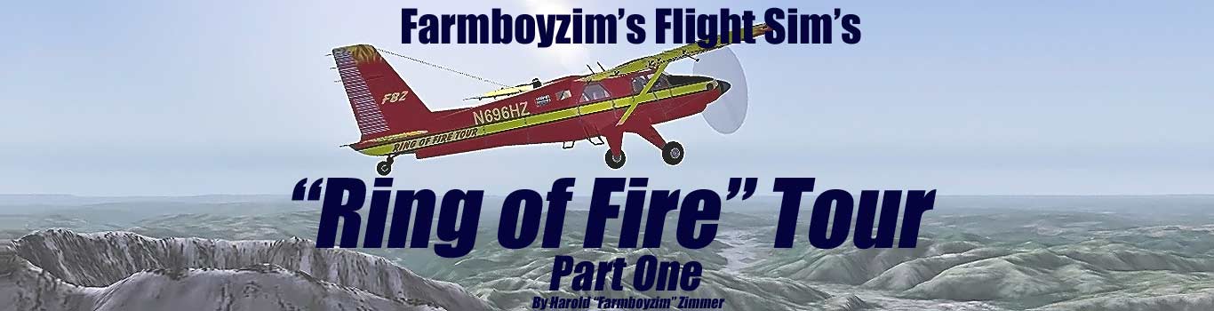
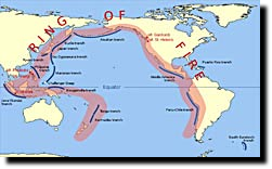
Here's a HUGE Round Robin Adventure for you! It all comes together by taking flights around the Ring of Fire (RoF). The RoF may be known to some of you, but for those that are not familiar with this phrase, it describes a ring of volcano's and seismic activity that encircles the Pacific Plate. Well talk about the RoF more in depth, as we explore along it's rim in a series of articles. These stories will also provide you with some ideas as to parts of the world that are yet to be "explored" by you, providing for some fun and exitingflying! Some of these areas that we will be flying out of and into, will often times be size restricted, pertaining to the type of aircraft we'll be using. Choice of aircraft is entirely up to you, however, I will provide information on the aircraft that I use to plan, and fly these routes.
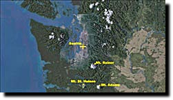
Well be starting in Washington State, USA for the tour, the beautiful Pacific Northwest (PNW). Well travel by various aircraft around this Ring, and see some very spectacular scenery. Ill also clue you in as to the availability of scenery packages, both freeware and payware, that would enhance the regions and airports and strips that we will be flying into.
Well be starting in Washington State, USA for the tour, the beautiful Pacific Northwest (PNW). Well travel by various aircraft around this Ring, and see some very spectacular scenery. Ill also clue you in as to the availability of scenery packages, both freeware and payware, that would enhance the regions and airports and strips that we will be flying into.
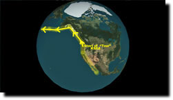
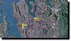
Course taken
For those of you that are new to the hobby of flight simming, Im going to start off slow and basic, and then progressively work in some more challenging aircraft and navigational skills. This will be a learning process for all of us, or simply a way to hone your skills further.
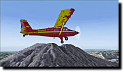
The Turbo Beaver I will be using for this first flight is by Premier Aircraft Design. I am flying this flight in MSFS 2004, with MegaScenery Pacific Northwest installed. This is going to look far different than the default terrain and mesh of MSFS 2004, but there are hosts of scenery packages both Payware and Freeware, that can be found to spice these areas up!
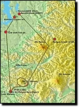
We are going to fly out of KSEA, south to intersect the TCM VOR. Then well travel onward until we sight some visual landmarks and land at the Mt. St. Helens Aero Ranch (WN10), for a brief visit and to test our skills on grass strips! This is an easy one folks! Well take off and circle Mt. St. Helens once, and head on a course that will take us by Mt. Rainer and finally, back to the Seattle area. We will land at Renton Municipal Airport (KRNT), which is better suited for our aircrafts needs. For the moment though, lets get up and at it! This trip is going to run a little over an hour and 30 minutes, give or take, in the Turbo Beaver, so travel times are going to vary as to what you choose to fly and how much side trip exploring you do. My flight took a little over 1 hour 45 minutes.
We are going to fly out of KSEA, south to intersect the TCM VOR. Then well travel onward until we sight some visual landmarks and land at the Mt. St. Helens Aero Ranch (WN10), for a brief visit and to test our skills on grass strips! This is an easy one folks! Well take off and circle Mt. St. Helens once, and head on a course that will take us by Mt. Rainer and finally, back to the Seattle area. We will land at Renton Municipal Airport (KRNT), which is better suited for our aircrafts needs. For the moment though, lets get up and at it! This trip is going to run a little over an hour and 30 minutes, give or take, in the Turbo Beaver, so travel times are going to vary as to what you choose to fly and how much side trip exploring you do. My flight took a little over 1 hour 45 minutes.
I decided to start from the PNW for a couple of reasons
Ive been to the areas personally, and the eye-candy of this area with its volcanos (most notably Mt. St. Helens), mountains, and valleys will hopefully entice you to join me on the complete journey and enjoy the ride! Since this is the first of a series of articles (I hope!), let me explain what the concept is behind this adventure, and how the aircraft will be chosen.
Each area that we will fly into will undoubtedly have some features that will be worth exploring in a leisurely fashion. Well be doing some General Aviation Flying along with a healthy dose of Bush Flying, as some of these areas are pretty secluded. We will need to cover some great distances on this tour, so well be utilizing a variety of aircraft, from private jets, small and large, large prop jobs, or small GA or Bush Type aircraft. Im hoping to mix it up a bit as far as aircraft are concerned, and will also include some helicopter tours whats a visit to a volcano if you cant hover above it! So let us begin our journey out of Seattle/Tacoma Intl, where, it just so happens, a "Custom" aircraft is waiting for us!
Each area that we will fly into will undoubtedly have some features that will be worth exploring in a leisurely fashion. Well be doing some General Aviation Flying along with a healthy dose of Bush Flying, as some of these areas are pretty secluded. We will need to cover some great distances on this tour, so well be utilizing a variety of aircraft, from private jets, small and large, large prop jobs, or small GA or Bush Type aircraft. Im hoping to mix it up a bit as far as aircraft are concerned, and will also include some helicopter tours whats a visit to a volcano if you cant hover above it! So let us begin our journey out of Seattle/Tacoma Intl, where, it just so happens, a "Custom" aircraft is waiting for us!
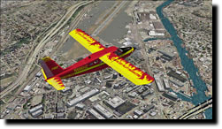
Over Seattle
KSEA INFO
Approaches: ILS, DME, LOC, VOR, RNAV, GPS
Attendance: Attended
Year-round, 7 Days a Week, All
Tower:ATCT plus Terminal Radar Approach Control, 24 hrs/day, everyday, year-round ATIS Hrs: 24 / Primary Approach Control Hrs: 24 / Primary Depart. Control Hrs: 24 / Tower Hrs: 24
Elevation: 433 ft (132.0 m) (Surveyed)
Location: 10 mi. S of Seattle
Beacon: Present (white-green)
Runways: 16C/34C, 16L/34R, 16R/34L
Longest paved runway: 11901 ft
Great Bush Plane!
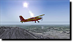
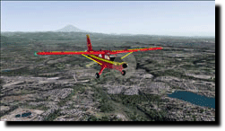
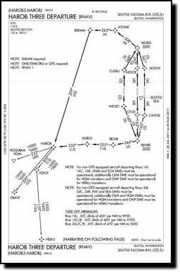
After getting clearance from KSEA Tower for a VFR flight, I took off (RW16L) and headed for the TCM VOR (109.60), and started climbing to an altitude of 12,500 feet. I wanted to make sure Id clear those mountain ranges off in the distance! I set the weather to clear with a visual distance of 50 miles, so we can see the visual flight landmarks I want you to look for. Its a little less than 20 miles to the TCM VOR from KSEA, and youll initially be passing over the Seattle area and its southern suburban areas. This scenery quickly starts to change into rolling hills, then the foothills, as we get closer to the mountain/volcano ranges.
Once you reach the TCM VOR, stay on its back course (336 to 340 degrees heading), or basically, stay on a 156 - 160 degree course. If you check the DME at about 22 miles or so out from TCM, you should have Mt. Rainer on your port wing (left). You can refer to your GPS if you wish at any time during the flight if your aircraft is equipped with one. If you want to use any available VORs or NDBs, feel free. Keeping an eye out for landmarks and recognizing the way from the air is quite fun and challenging as well. Well be doing a little bit of both.
Once you reach the TCM VOR, stay on its back course (336 to 340 degrees heading), or basically, stay on a 156 - 160 degree course. If you check the DME at about 22 miles or so out from TCM, you should have Mt. Rainer on your port wing (left). You can refer to your GPS if you wish at any time during the flight if your aircraft is equipped with one. If you want to use any available VORs or NDBs, feel free. Keeping an eye out for landmarks and recognizing the way from the air is quite fun and challenging as well. Well be doing a little bit of both.
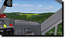
There are a couple of large lakes that run from east to west along the route to the Mt. St. Helens Aero Ranch (WN10), the first being Rifle Lake, about 40 miles or so south of the TCM VOR. You may want to start youre a descent around here if you want to land at WN10. About 60 miles out of TCM, you should be looking at Mt. St. Helens, again off your port wing. You should have noticed this landmark long before arriving at this point in your flight though. Your next landmark that youll see is more water
two lakes as a matter of fact, both running east to west and right next to each other. The lake on your left (the easternmost lake) will be Yale Lake, and Lake Merwin will be on your right. The Mt. St. Helens Aero Ranch lies right in between the two lakes. Before you get directly over the lakes, turn onto a heading of 147 - 150 degrees approximately, and keep an eye out for the grass strip that is WN10. Well be landing on runway 25. Go to the end of the runway as well be taking off from the far end, runway 07
So much to see!
Taking a breather at WN10
WN10 off starboard wing
Rifle Lake
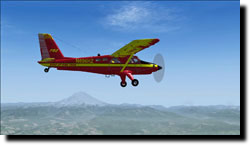
Passing by Mt. St. Helens
Mt. Rainer in distance
Approach to Mt. St. Helens Aero Ranch
Mount St Helen's Aero Ranch
Cougar, WA
Attendance: Attended Apr-Oct, 7 Days a Week, 0600-2200
Tower:No
Elevation: 450 ft (137.2 m) (Estimated)
Location: 5 mi. SW of Cougar
Beacon: Present
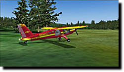
Runways: 07/25 (unpaved) (Grass)
Runway length: 2600 ft
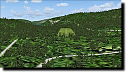
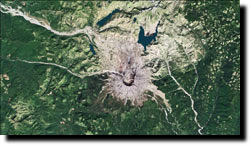
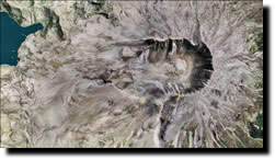
Get up, stretch your legs, grab some coffee or a water, and lets get airborne! The rest of the trip is rather easy, yet youll be seeing some of the worlds most beautiful landscapes, considering it is a virtual world! Take of on Runway 07 and start climbing. As soon as you can, take a heading of approximately 010 degrees. This should put you on course for Mt. St. Helens. It is rather hard to miss! I decided to circle the volcano and climb to a higher altitude, to see the inside of this cauldron of fire. Youll need to climb to about 12,000 feet or so, to get a good all around view of just how immense an event this eruption was. What you will see is a cap on the top of the cone of the volcano, emitting steam occasionally (MegaScenery package specific effects).
Cougar, WA
Attendance: Attended Apr-Oct, 7 Days a Week, 0600-2200
Tower:No
Elevation: 450 ft (137.2 m) (Estimated)
Location: 5 mi. SW of Cougar
Beacon: Present
Runways: 07/25 (unpaved) (Grass)
Runway length: 2600 ft
Get up, stretch your legs, grab some coffee or a water, and lets get airborne! The rest of the trip is rather easy, yet youll be seeing some of the worlds most beautiful landscapes, considering it is a virtual world! Take of on Runway 07 and start climbing. As soon as you can, take a heading of approximately 010 degrees. This should put you on course for Mt. St. Helens. It is rather hard to miss! I decided to circle the volcano and climb to a higher altitude, to see the inside of this cauldron of fire. Youll need to climb to about 12,000 feet or so, to get a good all around view of just how immense an event this eruption was. What you will see is a cap on the top of the cone of the volcano, emitting steam occasionally (MegaScenery package specific effects).
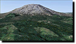
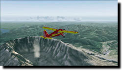
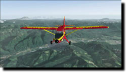
After circling the volcano in a counter-clockwise direction, take a bearing of 310 - 010 degrees. Youll be looking at Mt Rainier out in front of you. Over off your starboard (right) wing, you should see Mt. Adams in the distance. Why dont you put the sim on pause for a moment, hop outside your aircraft, and take a look at the surrounding mountains and ranges
it is truly a breathtaking sight, even if it is virtual! Snap away screen shooters! An abundance of photo ops here in this region! Stay on course towards Rainer, which should not be too hard to do, as it is a dominant feature in your windscreen, on this heading!
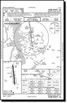
Once you get in the vicinity of Mt. Rainer, go ahead and tune in the SEA VOR, 116.80, and while youre at it, tune in the Renton (RNT) NDB, 353.0, as we will be landing at Renton Municipal (KRNT) on RW 33. Off to the northeast of Mt. Rainer, there is a little airstrip called Ranger Creek (21W). This strip is roughly 70 miles from Mt. St. Helens Aero Ranch (WN10), just in case youd like to make another short stop on the way back to the Seattle area. If not, circle Rainer and come to a heading of 315 - 320 degrees, and watch for the VOR needle to swing. Make any course corrections you need to for the SEA VOR, and give KSEA a holler, as youll be entering Class B airspace.
It certainly is a full circle of scenery on this short hop, going from city, to the mountains and volcanos, with all of their beautiful foot hills, and then back to civilization, which will be for our purposes KRNT.
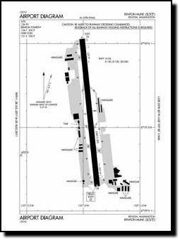
Renton Municipal Airport (KRNT)
Approaches: RNAV, GPS, NDB
Attendance: Attended Year-round, 7 Days a Week, 0700-Dusk
Tower: Air Traffic Control Tower, 13 hrs/day, everyday, year-round ATIS Hrs: 24Tower Hrs: OCT 1-APR 30 0700-2000; MAY 1-SEP 30 0700-2100
Elevation: 32 ft (9.8 m) (Surveyed)
Location: NW of Renton
Beacon: Present (white-green)
Runways: 16/34
Runway length: 5382 ft
Once you get in the vicinity of Mt. Rainer, go ahead and tune in the SEA VOR, 116.80, and while youre at it, tune in the Renton (RNT) NDB, 353.0, as we will be landing at Renton Municipal (KRNT) on RW 33. Off to the northeast of Mt. Rainer, there is a little airstrip called Ranger Creek (21W). This strip is roughly 70 miles from Mt. St. Helens Aero Ranch (WN10), just in case youd like to make another short stop on the way back to the Seattle area. If not, circle Rainer and come to a heading of 315 - 320 degrees, and watch for the VOR needle to swing. Make any course corrections you need to for the SEA VOR, and give KSEA a holler, as youll be entering Class B airspace.
It certainly is a full circle of scenery on this short hop, going from city, to the mountains and volcanos, with all of their beautiful foot hills, and then back to civilization, which will be for our purposes KRNT.
Renton Municipal Airport (KRNT)
Approaches: RNAV, GPS, NDB
Attendance: Attended Year-round, 7 Days a Week, 0700-Dusk
Tower: Air Traffic Control Tower, 13 hrs/day, everyday, year-round ATIS Hrs: 24Tower Hrs: OCT 1-APR 30 0700-2000; MAY 1-SEP 30 0700-2100
Elevation: 32 ft (9.8 m) (Surveyed)
Location: NW of Renton
Beacon: Present (white-green)
Runways: 16/34
Runway length: 5382 ft
Youll pick up the RNT NDB which will direct you into KRNT. I was cleared for a straight in approach for RW 34. KRNT can be a busy airport and handles quite a bit of traffic. It is located within the airspace control of KSEA, hence the request for permission to transit the Class B airspace. KRNT offers an easy approach, with no obstacles.
The primary scenery enhancement for this flight is MegaScenery Pacific Northwest for MSFS 2004. These areas are covered in detail for FSX as well.
I hope you enjoyed this first of what I hope is many hops around the Ring of Fire! For those that are interested, here is a brief list and description of just a few of the freeware scenery packages that are out there
FSX Seattle Airport Scenery - seatac_jd.zip Size: 389,750
Adds the third runway that is in the real world airport, runway 34C. Includes all ILS approaches for each runway and other extras. Created by J. D. Starseed.
FS2004 AFCAD2 File for KSEA - ksea_afcad.zip This scenery includes accurate up-to-date parking spots with airline assignments and correct gate numbers, updated tower viewpoint, and most important, the addition of the new runway 16R/34L. Takeoffs will exclusively occur on 16L/34R, while landings will share runways 16C/34C and the new 16R/34L. Created by Alex McKnight.
FS2004 Scenery--Renton and Crater Lake - rentcrat.zip - Adds a fire department / search and rescue facility at the default Renton Airport (KRNT), Washington (WA). Also adds a paved runway and parking on the island in the middle of Crater Lake, Oregon (OR). Created by Leon Nel.
FS2004 Scenery--Mount St. Helens Volcanic - sthlnash.zip - Photorealistic coverage for the area of Mount Saint Helens. Created by Raimondo Taburet.
FS2004 Scenery - Mt. Rainier National Park - mrnp1.zip - Based upon commercial topographic maps, the designed scenery includes every hiking trail drawn in meticulous detail including every real life switchback; every lake and small alpine pond 20 feet in diameter and over, modified landclass of alpine, forest and rock; every perennial and many intermittent creeks, all steams and rivers (many braided), glacier mapping of every glacier with custom textures and ice fields on the mountain, mapping of all rock faces and rock, moraine rock deposits, glacier outwash area, mudflows, roads, swamp and marsh areas.
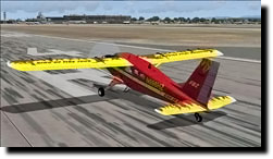
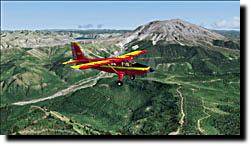
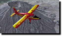
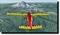
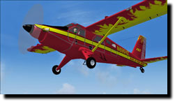
The aircraft for this flight is the DeHavilland Turbo Beaver from Premier Aircraft Design and is a freeware addon. Even though this is an older model, I still enjoy flying it often. Its a great aircraft for getting in and out of small grass strips, and has power enough to get a good climb rate and cruise speed. Unfortunately, as of this writing, one of PADs key members, Jean Pierre Brisard has passed away, and no plans thus far have been announced by PAD to continue producing, what I believe is some outstanding freeware. The Ring of Fire paint job is by yours truly! Im no Rembrandt, but it was fun to do using both Abacus FS Repaint and Adobe Photoshop Elements 3.0. The aircraft is easily found by doing a search of any major flight sim website.
Well see you in the next issue as we head north to .youll just have to see!
Have a great flight!
~Farmboyzim~
The primary scenery enhancement for this flight is MegaScenery Pacific Northwest for MSFS 2004. These areas are covered in detail for FSX as well.
I hope you enjoyed this first of what I hope is many hops around the Ring of Fire! For those that are interested, here is a brief list and description of just a few of the freeware scenery packages that are out there
FSX Seattle Airport Scenery - seatac_jd.zip Size: 389,750
Adds the third runway that is in the real world airport, runway 34C. Includes all ILS approaches for each runway and other extras. Created by J. D. Starseed.
FS2004 AFCAD2 File for KSEA - ksea_afcad.zip This scenery includes accurate up-to-date parking spots with airline assignments and correct gate numbers, updated tower viewpoint, and most important, the addition of the new runway 16R/34L. Takeoffs will exclusively occur on 16L/34R, while landings will share runways 16C/34C and the new 16R/34L. Created by Alex McKnight.
FS2004 Scenery--Renton and Crater Lake - rentcrat.zip - Adds a fire department / search and rescue facility at the default Renton Airport (KRNT), Washington (WA). Also adds a paved runway and parking on the island in the middle of Crater Lake, Oregon (OR). Created by Leon Nel.
FS2004 Scenery--Mount St. Helens Volcanic - sthlnash.zip - Photorealistic coverage for the area of Mount Saint Helens. Created by Raimondo Taburet.
FS2004 Scenery - Mt. Rainier National Park - mrnp1.zip - Based upon commercial topographic maps, the designed scenery includes every hiking trail drawn in meticulous detail including every real life switchback; every lake and small alpine pond 20 feet in diameter and over, modified landclass of alpine, forest and rock; every perennial and many intermittent creeks, all steams and rivers (many braided), glacier mapping of every glacier with custom textures and ice fields on the mountain, mapping of all rock faces and rock, moraine rock deposits, glacier outwash area, mudflows, roads, swamp and marsh areas.
The aircraft for this flight is the DeHavilland Turbo Beaver from Premier Aircraft Design and is a freeware addon. Even though this is an older model, I still enjoy flying it often. Its a great aircraft for getting in and out of small grass strips, and has power enough to get a good climb rate and cruise speed. Unfortunately, as of this writing, one of PADs key members, Jean Pierre Brisard has passed away, and no plans thus far have been announced by PAD to continue producing, what I believe is some outstanding freeware. The Ring of Fire paint job is by yours truly! Im no Rembrandt, but it was fun to do using both Abacus FS Repaint and Adobe Photoshop Elements 3.0. The aircraft is easily found by doing a search of any major flight sim website.
Well see you in the next issue as we head north to .youll just have to see!
Have a great flight!
~Farmboyzim~
Close up of the cone
Getting altitude to see inside the volcano
Double click to edit
Mt. St. Helens - Top Down View
Mt. St. Helens area of damage
Mt. St. Helens dead ahead!
Steam still present
KRNT
KRNT Diagram
KRNT approach chart
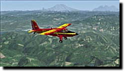
Pacific Northwest - Volcano Land!
Top down view of staging area
Ring of Fire Map
Ring of Fire Turbo Beaver
Course taken
Farmboyzim's Flight Sim's © Copyright 2005 - 2012 All rights reserved. No reproduction in any manner may be made of content written by the author, without express, written permission of the author. All logos and trademarks on this site are property of the respective owners.
The comments made are property of their authors.
Use of this site constitutes agreement and consent to the Privacy Policy
The comments made are property of their authors.
Use of this site constitutes agreement and consent to the Privacy Policy

Thanks For The Visit !
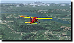
Off towards Mt. Rainer
Renton Municipal off to the right
Back to the Seattle area
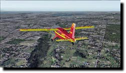
Rolling Hills or Mountains...
Departure Chart KSEA
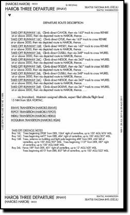
Departure instructions KSEA
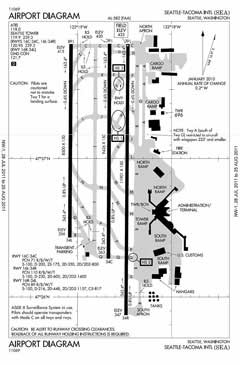
KSEA Diagram